8 stages · 205 km

Gradients and elevation

Ascents: 950m
Descents: 956m
Lowest point: 0m
Highest point: 306m

Road types

63km (31%) By road
143km (69%) Cycle path

Surface

31km (161%) Smooth
0.28km (1%) Unknown
7km (37%) Rough

8 stages used

Saint-Jean-de-Daye / Carentan-les-Marais

24 Saint-Jean-de-Daye / Carentan-les-Marais

19 km
1 h 16 min
Beginners/Families
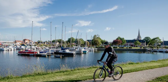
You leave behind the typical Normandy hedge-divided fields to enter wetlands boasting an impressive network of channels and canals. The Vélomaritime here also leads you into the heart of one of France's main horse-breeding areas. Keep your eyes peeled for signs indicating the way to local racecourses. Reaching Carentan, nestled in the Baie des Veys, its yachting harbour immediately takes you back to a coastal atmosphere on your cycling adventure.
Saint-Lô / Saint-Jean-de-Daye

23 Saint-Lô / Saint-Jean-de-Daye

23 km
1 h 30 min
Beginners/Families
The dynamic town of Saint-Lô, despite being heavily bombed in 1944 as World War II was reaching a climax in France, has preserved an exceptional heritage, notably the national stud farm, the Haras National, which you can visit, and the town's medieval ramparts. The Vélomaritime cycle route then continues beside the Vire Canal, meandering along up to St-Jean-de-Daye, through picture-postcard countryside.
Pont-Farcy / Saint-Lô

22 Pont-Farcy / Saint-Lô

32 km
2 h 06 min
Beginners/Families
Your cycling trip continues gently along the picture-postcard Vire towpath, with peaceful meadows where sheep and horses graze, wild hedges full of flowers in season, and enchanting villages, including lively little Tessy-sur-Vire. Along the way, don't miss the detour to Les Roches de Ham, providing spectacular views over the Vire Valley and the Pays Saint-Lois area. The Vire's waters long attracted numerous craftspeople, including weavers, tanners and washerwomen, while many barges, houseboats and gabarres, traditional boats, are still to be seen along this picturesque valley.
Vire Normandie / Pont-Farcy

21 Vire Normandie / Pont-Farcy

36 km
2 h 10 min
I cycle often
The Vire Valley acts as the thread along this Vélomaritime stage. After a stretch of greenway, you ride along minor roads through Normandy hedge-row-divided fields and valleys. With its ups and downs, this stage provides splendid views over the Vire's meanders and leads to La Ferrière-Harang, followed by the peaceful village of Pont-Farcy, nestled in a green corner beside the river. Highlight of the day is perhaps cycling under the grand Souleuvre Viaduct.
Mortain-Bocage / Vire Normandie

20 Mortain-Bocage / Vire Normandie

43 km
2 h 50 min
Beginners/Families
The sound of the largest waterfalls in northwest France still ringing in your ears, continue riding along a greenway through the hedge-divided fields of the Normandy bocage. Here, green dominates the scene and the typical Normandy countryside imparts a feeling of well-being. Once past Sourdeval, the Vélomaritime route leads on to Vire, a town rebuilt after the 1944 Allied bombings. The place has preserved its lively traditional market and is reputed for its culinary and craft heritage.
Saint-Hilaire-du-Harcouët / Mortain-Bocage

19 Saint-Hilaire-du-Harcouët / Mortain-Bocage

11 km
43 min
Beginners/Families
Leading you along slopes, this Vélomaritime stage guides you gently towards Mortain, at the green heart of Normandy's extensive area of typical hedge-divided fields, known as the bocage, and located where our route meets the Véloscénie cycle route. The greenway on this stage takes you close to the enchanting Cance waterfall. Do go and see it in its wild, steep setting, clearly showing how this part of Normandy is part of the wider Armorican granite peninsula.
Ducey-Les Chéris / Saint-Hilaire-du-Harcouët

18 Ducey-Les Chéris / Saint-Hilaire-du-Harcouët

19 km
1 h 15 min
I cycle often
This Vélomaritime stage shares the way with the Véloscénie cycle route, taking you along a former railway track converted into a greenway, leading to St-Hilaire du Harcouët. Founded and fortified by a comrade-in-arms to William the Conqueror, this fortress town strategically placed between the Cotentin Peninsula, Brittany and French Maine (now in the Pays de la Loire Region) offers a variety of activities in summer based around the Plans d'eau du Prieuré, a series of lakes.
Mont-Saint-Michel / Ducey-Les Chéris

17 Mont-Saint-Michel / Ducey-Les Chéris

22 km
2 h 03 min
Beginners/Families
The Vélomaritime route leaves Normandy's Marvel behind, taking you via a greenway through the salt meadows. Make the most of the last glimpses you're afforded across to the Mont Saint-Michel set in its great bay before reaching the Sélune Estuary, your gateway to the traditional bocage normand landscapes, consisting of hedge-divided fields. An other lovely greenway leads you gently to the centre of the well-flowered village of Ducey.

The Vélomaritime route leaves La Merveille via
Afficher les étapes