All stages on La Vélomaritime / EuroVelo 4
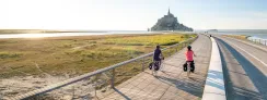
Perros-Guirec / Tréguier
CRTB / A. Lamoureux 
CRTB / A. Lamoureux 
From Perros-Guirec, the Vélomaritime climbs to an agricultural plateau and then heads towards the little city of Tréguier. At the end of this stage, you descend to the Jaudy Estuary, where Tréguier, designated a Petite Cité de Caractère for its cultural riches, is a lovely place to enjoy a well-deserved rest.
Gradients and elevation
Ascents: 146m
Descents: 141m
Lowest point: 1m
Highest point: 99m
Road types
16km (71%) By road
7km (29%) Cycle path
Surface
16km (70%) Smooth
3km (11%) Rough
4km (18%) Unpaved
The route
Mainly along minor roads. Take care: with the busy traffic around Perros-Guirec and north of Tréguier; crossing the RD70 road.
Link
From the route a connection allows you to reach the town of Plougrescant (7 km).